In a complex, data-rich world, organizations are under pressure to move faster, operate smarter, and make real-time decisions. Blue Hammer delivers AI-driven platforms that transform unstructured data into predictive insight across transportation corridors, maritime zones, manufacturing plants, and agricultural fields. Our solutions automate risk detection, unlock hidden value, and drive measurable results in mission-critical environments.
critical insights
Operational Clarity
Torrent ™
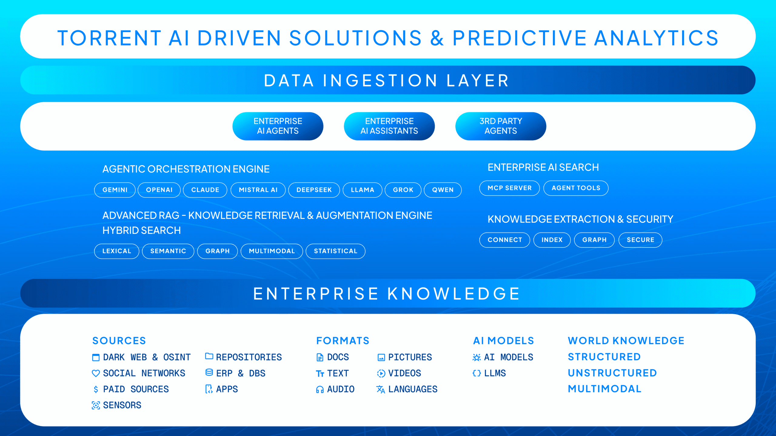
At the core of Blue Hammer Technology’s intelligence platform is Torrent™, an AI-native engine that unifies fragmented data—from sensors, cameras, devices, ISR feeds, and historical systems—into a single, real-time operational picture. Powered by ACORe™, Torrent delivers advanced object identification, correlative intelligence, and anomaly detection to expose hidden threats, patterns, and opportunities across national security, border protection, and critical infrastructure environments—transforming raw data into decisive, mission-ready intelligence.
Ingests and normalizes fragmented data sources—video, sensors, logs, satellite, and more—into a single, structured intelligence layer, transforming raw inputs into actionable, real-time insights.
AI-Native Recognition Powered by ACORe™
Leverages advanced character and object recognition to automatically identify, label, and classify entities across massive data streams with high accuracy and speed.
Real-Time Labeling & Decisioning
Continuously processes live data feeds to detect events, tag critical attributes, and trigger immediate alerts—enabling faster, more informed operational responses.
Correlative Forensics & Pattern-of-Life Analysis
Links data across time, location, and modality to uncover hidden relationships, reconstruct events, and build comprehensive forensic intelligence for investigation and enforcement.
Predictive Analytics & Operational Foresight
Applies machine learning and adaptive analytics to anticipate risks, detect anomalies, and forecast outcomes—shifting operations from reactive to proactive decision-making.
Sovereign, Scalable, Proven
Trusted AI Platforms
Blue Hammer’s platforms deliver these outcomes across public sector and critical infrastructure domains.
Tailored Solutions
Modular, interoperable solutions tailored for sovereign deployment that turn data into strategic assets.
Proven Expertise
Decades of experience with defense agencies, toll authorities, port operators, and commercial producers.
Mission Ready
Mission-ready AI models designed for real-world operational impact.
Predictive Analytics
Embedding predictive analytics to move clients from fragmented reporting to intelligent foresight.
real World Impact
measurable gains
The power of predictive analytics is no longer theoretical, it’s operational and proven.
0%
possible improvement in supply chain forecasting accuracy
0%
reduction in manufacturing downtime
0%
higher crop yields with AI-driven agricultural monitoring
The Cost of Falling Behind
What’s at Risk Without Torrent AI
Failing to deploy an AI platform like Torrent AI can lead to:
Delayed Threat Detection – Missed identification of active threats
Misclassification of Risks – Overlooking high-risk individuals or assets
Higher Costs – Manual labeling is expensive and inefficient
Compliance Gaps –Regulatory risks in defense, telecom, and other sensitive sectors
Unified Data Processing at Any Scale
From Ingestion to Insight
Torrent™ ingests and transforms massive, diverse datasets from:
IoT & Diagnostics
Fuel, engine, tire, and sensor data
Contextual Inputs
Weather, traffic, and road hazard info
Legacy Data Lakes
CCTV, satellite, and drone imagery
Legacy Data Lakes
Unlabeled archives and historic logs
Structured through bi-directional APIs and processed by: